In a recent post we talked about the classification of technical difficulty of mountain bike trails by describing two different scales, here is the article. No trail is homogeneous from the beginning to the end with respect to its overall difficulty level: typically a trail classified as S3 of the Singletrail Skala, in short STS (see the linked article) can contain many segments of lower difficulty and may even have short S4 sections.
So it would be interesting to know for a given trail how many meters of this are classified S0, S1, S2 and so on. All we need are the data and a little program to process them. In our case we are lucky, in OpenStreetMap some volunteer mappers took the trouble to classify individual portions of our trails; we have written an ad-hoc computer program and in this post we present the obtained results.
The trails we have taken into consideration are those described in the specific section of our site; they are all single-track, typically downhill (e-bikes apart) and the classification takes these features into account. These are:
| Trail | Length |
| 3 Pozzi | 2336 m. |
| Anxur (anche noto come Fossata) | 963 m. |
| Fondo Chiuso (anche noto come Ciana) | 2150 m. |
| Forcola | 1828 m. |
| Francolane | 1108 m. |
| Grandine (anche noto come Variante) | 1583 m. |
| Mammolini (insieme alla variante raw) | 3585 m. |
| Monte Romano | 4217 m. |
| Poiana | 2333 m. |
| tot = 20104 m. |
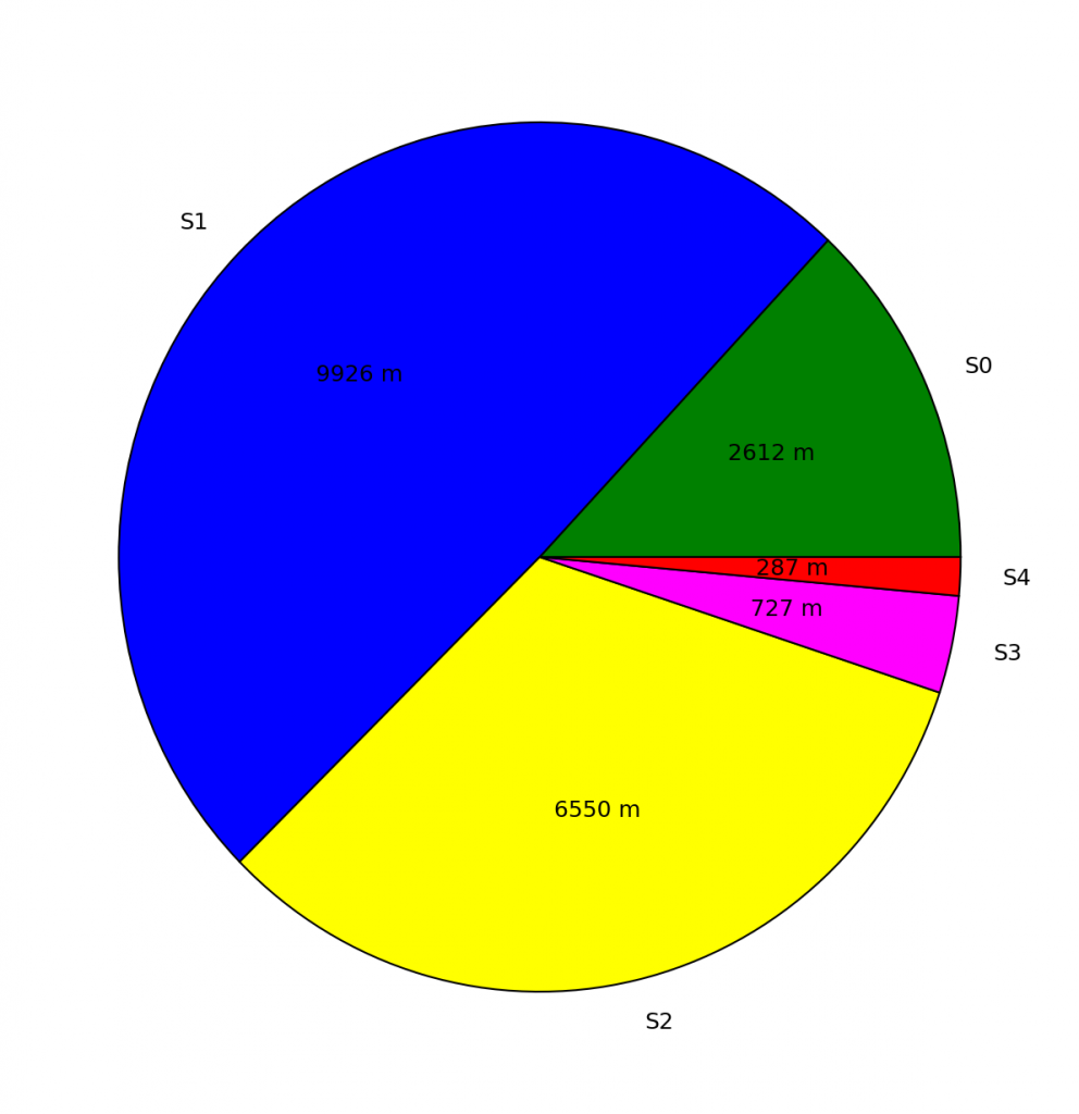
Let’s start with a pie-chart that shows how the difficulty levels of the 20 km of trails in the entire network are divided.

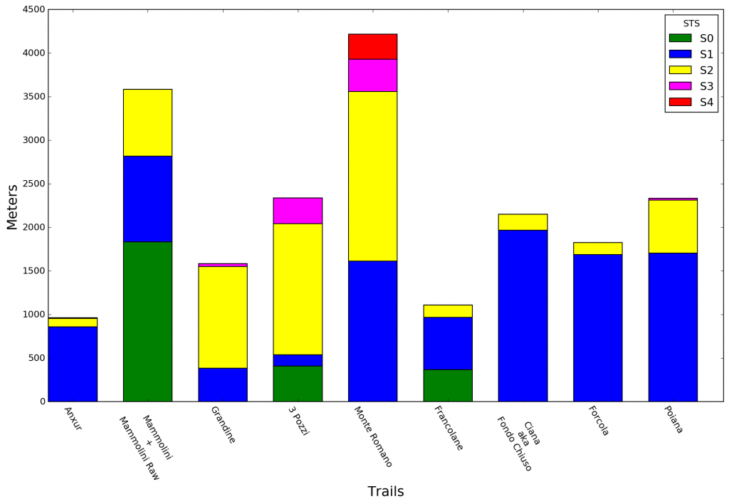
The following bar-chart shows for each trail the overall length of its portions which fall into the various levels of difficulty of the STS which are represented with different colors.

The next question could be: what is the most difficult trail? With the data we have we can try to give an answer by attributing to each trail a numerical value that defines its overall difficulty coefficient. We get this number computing an average of all the difficulty levels of the trail weighed with the fractions of the path lengths that fall into that level. That is, we sum the total lengths of the sections of the trail that fall within a certain level of the scale multiplied by a factor that depends on the level (1 for S0, 2 for S1, 3 for S3 and so on) all this divided by the total length of the trail. For example, for Poiana, 1703 meters are classified S1, 610 meters are classified S2 and 21 meters are classified S3; therefore the difficulty coefficient results
(17032 + 6093 + 21*4)/2333 = 2.279
Here’s what we get by applying our formula on all the trails.
| Monte Romano | 2.84 |
| Grandine | 2.78 |
| 3 Pozzi | 2.72 |
| Poiana | 2.28 |
| Anxur | 2.12 |
| Fondo Chiuso | 2.08 |
| Forcola | 2.07 |
| Francolane | 1.80 |
| Mammolini + Mammolini Raw | 1.70 |
Therefore, according to our method, we get that the most challenging trail is Monte Romano, then Grandine, 3 Pozzi and so on. Note that this definition being an average only takes into account the technical aspect and not the length of the trails.


 Italian